Many thanks to all who donated to NRPA through 401Gives in 2025!
401 Gives is a once a year statewide “day of giving”.
This program was launched by United Way of Rhode Island in 2020 when on-profit organizations were unable to gather in their traditional ways. Each year since then, the program has grown in participation and giving with very creative ways to multiply your individual contributions.
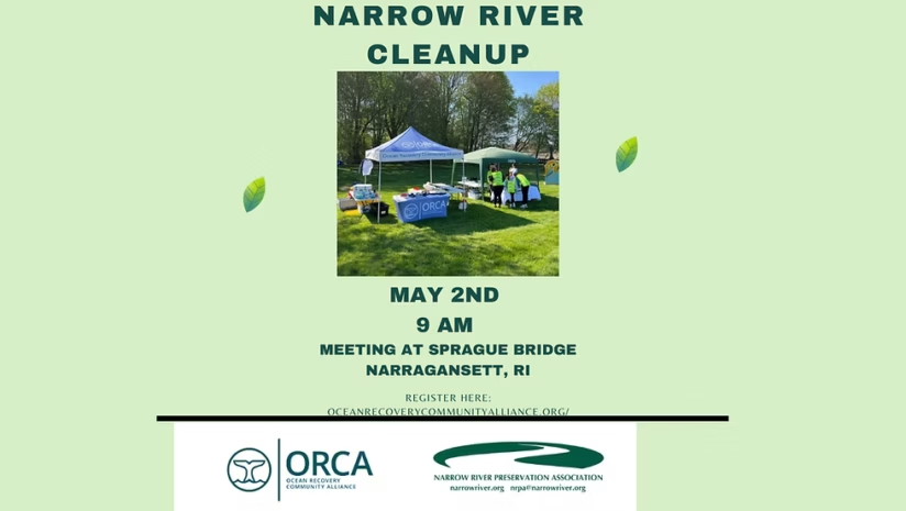
The 2026 Narrow River cleanup is planned for Saturday, May 2, 2026.
ORCA is partnering with the Narrow River Preservation Association to clean up the Narrow River (Pettaquamscutt Estuary) Watershed. We’ll meet at 9am at the Sprague Bridge parking lot, then fan out to pick up litter along the roads, parks, and parking lots of the Narrow River watershed.
Saturday, April 18, 2026 10am at Mettatuxet Yacht Club
You are invited to SUBMIT BOATING QUESTIONS using this form.
From this online survey, NRPA will assemble questions for review at the meeting and to be added to our ‘Frequently Asked Questions’ on our webpage with our answers to questions submitted here.
As always, feel free to email us at nrpa@narrowriver.org with any questions. Thank you! Thanks!
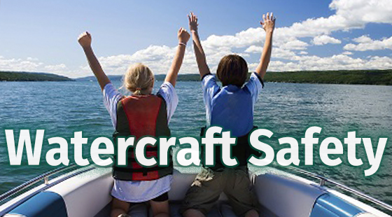
Navigating the Narrow will provide information to boaters, kayakers, paddle boarders and all who simply love the Narrow River about safely and responsibly enjoying this amazing natural resource.
Navigating the Narrow: A Guide to Boating on the Narrow River
Many residents and visitors to the Narrow River enjoy kayaking, canoeing, paddle boarding and boating. These are some of the best ways to enjoy the watershed. Narrow River Preservation Association (NRPA) works to preserve, protect, and restore the natural environment and quality of life for all communities within the Narrow River (Pettaquamscutt Estuary) and Watershed. This includes those who utilize the watershed in boats and personal and paddle watercraft.
NRPA Supports and Encourages Safe and Responsible Boating on the Narrow River!
The Narrow River is a beautifully unique waterway tidal estuary that flows from its headwaters in North Kingstown to the Atlantic Ocean. Despite the serene and calm environment, the dynamic nature of the waterway presents many risks to boaters. Wind direction, travel direction, and tide height need to be considered every time you go out on the water.
Navigating the Narrow River is under the jurisdiction of the United States Coast Guard (USCG), Rhode Island Department of Environmental Management (DEM), and three local municipalities of Narragansett, North Kingstown, and South Kingstown. Each municipality has their own harbor master who is responsible for rule enforcement. Safe and responsible boating requires the proper attention and education of boaters.
No Wake Zone Map for Lower Narrow River. Source: 2016 Narragansett Harbor Plan. Click the map for a larger version.
Navigating the Narrow: Safe & Responsible Boating
Be Prepared — Plan for your trip!
Plan: Create a Float Plan (an overview of a boat excursion that can give authorities a head start in looking for a boater if he or she fails to reach his or her destination) and stick to it.
Boat: Perform a Safety Check and verify the boat is in good working order.
Weather: Watch for inclement weather and be aware of changing conditions.
Passengers: Verify your passengers know the proper safety procedures in the event of an emergency.
Life jackets are essential!
Always wear a life jacket and make sure it fits properly.
BY LAW kayaks, canoes and paddle boards require life jackets.
Children under 13 must always wear a life jacket on motorboats.
Know the River. Make sure you know where you are going and how you are getting there. The Narrow River changes season to season and with significant weather events.
Tides: High tide or low tide, time your trip accordingly. Be aware of low tide obstructions such as sandbars. Click this link for the Narrow River Tide Chart.
Know where the No Wake Zones are and obey speed restrictions.
When traveling under a bridge, check the direction of the current and adjust your speed so you can control your boat in the tight area.
When beaching your boat, always go against the current so you have steerage at low speed and always have a stern anchor to keep the boat aligned.
Follow the Boating Rules:
Be courteous to others on the water (people, waterfowl, and animals).
Power driven vessels ALWAYS give way to non-powered vessels (sail boats and human powered watercraft)
Don’t overload the boat with people or equipment.
Treat your fueling operations with care.
Practice proper boat propeller safety.
Check for harmful fumes.
Follow proper anchoring procedures (do not anchor in protected areas or in the navigable channel).
Follow proper docking procedures.
Follow proper lighting for night navigation.
Know your boat’s maximum passenger capacity.
Ensure your boat is properly maintained and serviced.
DO NOT DRINK AND BOAT. In Rhode Island, it’s illegal to operate or drive any watercraft while under the influences of drugs or alcohol.
RIDEM (Rhode Island Department of Environmental Management) and USCG (United Stated Coast Guard) websites have many resources to reference.
Exercise good judgment and use common sense on the water.
Frequently Asked Questions
Who should I call if I witness a boating accident or other emergency on the river?
Call 911 for all life safety and significant emergencies. An RIDEM Rhode Island Boating Accident Report must be filled out by the owner/operator of any vessel that is involved in a boating accident–on the inland waters and the coastal waters contiguous to this state–that meets the following criteria:
Loss of life or disappearance from a vessel.
Injury to any person that requires medical treatment beyond ordinary first aid. If you go to the emergency room or call a rescue, it is beyond first aid.
Property damage in excess of $2,000 (combined damage to both vessels, if more than one vessel is involved.)
Complete loss of a vessel.
If more than one vessel is involved the owner/operator of all vessels must fill out and file a boating accident report.
Reportable accidents must be submitted within five (5) days after the incident on forms provided by the department. Accidents must be reported to the state authorities where the accident occurred.
What should I do if I witness a boater breaking the law?
People who spot boaters making a wake or otherwise breaking the law are encouraged to call the Municipal Harbormaster. If a boater is doing something particularly egregious, you are encouraged to photograph the boat (including identification numbers) and email the photo and a description of the offense to the Harbormaster:
What do I need to be aware of regarding preservation of the river?
NRPA has many ongoing water quality and watershed preservation programs. Boaters should be respectful of the natural habitats therein and do their best not to disturb them.
Photo courtesy of Margaret McGregor.
Studies on water quality and clarity found that boats did have a noticeable impact. The presence of vessels seemed to increase the growth of algae and kick up sediments, both of which obstruct sunlight and spoil the water.
Additionally, deposits left from boats can change the water’s chemistry and a decrease in water quality is bad for both wildlife and humans. A large amount of impairment to wildlife is also caused by smaller, less noticeable aspects of boats. Chemicals used to clean, protect, and run watercraft often leach into the water, severely impacting the environment and weakening or killing the wildlife. Aquatic plants and animals have specific requirements for light, temperature, pH level, etc. Toxins from detergents, paints, petroleum products, batteries, and metals have disastrous effects on wildlife’s ability to survive and thrive, including cancer, mutations, birth defects, and outright death.
NRPA suggests measures such as the following to help mitigate any negative impacts people or watercraft may have on the river and its inhabitants:
Observe No Wake Zones: proper speed control in No Wake Zones will help preserve the habitat in these areas by reducing the amount of erosion of the shoreline.
Maintain boat engines so they do not leak fuel into the river.
Safely dispense of fuel and oil to prevent any leakage into the river.
Use environmentally-friendly cleaners and rinse thoroughly away from the river, if possible.
What should I be aware of regarding the river’s flow, tides and dynamics?
The Narrow River is in constant motion. The daily tides affect the river’s flow, shoreline and salinity levels. They are influenced by lunar and seasonal fluctuations and weather events.
The Narrow River is not a navigable waterway. Its boating channels are not professionally maintained. Depths at low tide can be as low as one foot in the boating lanes, with sandbars surfacing above the water level.
Clearance under the Middle and Lacey/Bridgetown Bridges varies with the tides and weather conditions. The clearance can be as low as four feet.
High and low tides are caused by the moon. The moon’s gravitational pull generates something called the tidal force. The tidal force causes Earth—and its water—to bulge out on the side closest to the moon and the side farthest from the moon. These bulges of water are high tides.
Two high tides and two low tides happen every 24 hours and 50 minutes. Their time varies throughout the year. Click this link for the Narrow River Tide Chart.
The flow at the mouth of the river allows the ocean water to come into the river. The Narrow River has salinity well into the upper reaches above Lacey Bridge (Bridgetown Road). At dead low tide it looks like the river is blocked off from the ocean. The river has been blocked by sand at its mouth during extreme weather conditions. These events are temporary, and Mother Nature finds way to return the river to its normal conditions.
What are the boating certification requirements?
The following are Boating Certification Requirements:
All boat operators born after January 1, 1986.
All operators of personal watercraft (jet ski), regardless of age and regardless of residency
Out-of-State Residents operating a vessel (other than a Personal Watercraft-see above), must meet the requirements of their home state in order to operate in Rhode Island Waters. For questions, contact DEM/Environmental Police at (401) 222-3070.
What are the boating rules and are they different for different parts of the Narrow River?
The Narrow River is under the jurisdiction of the United States Coast Guard (USCG), Rhode Island Department of Environmental Management (DEM), and three local municipalities (Narragansett, North Kingstown, and South Kingstown). Each municipality has their own harbor master. RIDEM and the USCG websites have many resources to reference.
The rules for boating are not different in different parts of the river, but each area has its own topography. Safe and responsible boating requires proper attention by boaters in all areas. The lakes are open deep areas with some shallow areas, the narrows are tight areas and mostly No Wake Zones, the beach area is more affected by the tide and has more varying sand bars, and the mouth of the river is difficult to navigate.
How can boaters and kayakers best interact?
Motorboats must to yield to paddle craft and maintain control of their boat at all times. Just because there is a local channel that boaters use due to the water depths, motorboats must still operate with due care around paddle craft regardless of where they are.
Paddle craft should be courteous by staying clear of the areas that are better suited to power boats whenever possible. Paddle craft should be respectful of motor boat channels, watch for moving boats, and minimize their time in the motor boating lanes. These channels are narrow and fast moving and motor boats do not have much room to maneuver within them, especially during low tide.
Click the map for a larger sized map.
What are No Wake Zones and where are they?
“No Wake” means operating a boat at the slowest speed necessary to maintain steerage and that reduces or eliminates waves that appear as white water behind the boat.
Current laws stipulate no wake under bridges, around mooring fields, near docks and near swimming areas, and, although the inlet to the river is not marked as a No Wake Zone, is a safe practice to observe there. While the motor boating channel cannot be better marked at this time, the speed limit must meet the above definition.
South Kingstown Ordinance 4-5.4 states the following for No Wake Zones on the Narrow River: “No vessel shall be operated in excess of five (5) miles per hour and/or create a wake within the area from Hahn Avenue to four hundred (400) feet north of Radial Drive, in the Narrow River.” If you witness someone making a wake in a No Wake Zone, contact the Municipal Harbormaster.
Wakes are not permitted near docks.
As for the speed limit outside of No Wake Zones, boaters need to be safe and responsible. R.I.G.L 46-22-9.5 Speeding regulates speed on RI waters as follows, unless local regulations are more restrictive: “(a) No person shall operate any motor-boat or vessel in any harbor or inlet or any pond or other confined body of water in this state in excess of forty-five (45) miles per hour during the hours from sunrise to sunset and twenty-five (25) miles per hour during periods of darkness or other periods of restricted visibility; provided, however, nothing herein shall prohibit the posting of lesser speed limits where deemed necessary by the appropriate state or local authority.”
Access to the River-There is no limit of the number of boats or paddle craft allowed on the river. Boaters and paddlers should always take care when navigating the river, especially when it is being heavily used.
Recreation users riding the tide such as large inflatables (inflatable ducks, swans, alligators, frogs, creating a human chain, without steerage/paddle power) should use extreme caution and must also follow safe navigation practices and be courteous of the boaters and paddle craft.
What are best practices for fueling a boat?
When fueling a boat, you should observe the same rules as when fueling a vehicle combined with a few additional precautions specific to the water:
No matter where you are refueling, always clear the area of anyone not directly involved with fueling the boat.
Put out all smoking materials and secure your boat to the dock.
Turn off engine(s) and electronics, and extinguish all open flames.
Fueling your boat with a portable container can take time, make sure your container is comfortable to carry, hold and balance.
Portable containers and Jerry Jugs can be spill prone so go slowly, pour deliberately and watch you container (especially the nozzle mechanism) for signs of wear.
Keep the nozzle in contact with the edge of the fill to prevent build-up of static electricity and sparking.
Don’t top off your tank. Know how much fuel your tank holds and fill it to about 90%. Fuel expands as the temperatures rises.
Clean up fuel spills immediately with an oil-only absorbent pad. Wipe down the bilge or any interior parts that may have come in contact with fuel.
Treat your fueling operations with care. Never use hands-free clips and avoid any distractions while fueling.
On the dock, put an absorbent pad under the container.
Consider using a funnel. A filtered funnel will help prevent contaminants from entering the fuel tank.
Ensure the nozzle stays in contact with the tank opening.
Always store portable fuel tanks out of direct sunlight and keep in a cool, dry place to minimize condensation.
**Scroll below for many photos, videos and explanations of the science behind overturns!**
An unusual (but not abnormal) event happened in Upper Pond on Narrow River on Saturday, November 16, 2024. It was an overturn (also called a ventilation) of the bottom waters. This drone video by Steve Carey shows the effect.
If you were near or overlooking Upper Pond, you saw the milky colored water and smelled hydrogen sulfide (the rotten egg smell). The bottom waters in the deep ponds of Narrow River are naturally anoxic, meaning without oxygen.
WJAR Channel 10 featured NRPA explaining the science behind the Overturn. Click here to see the report.
Overturns occur in the deep ponds of Narrow River when there are certain weather conditions: a dry fall, cooler temperatures, and blustery winds. This occurred Saturday because the dry fall meant less freshwater entered from Gilbert Stuart Stream and the King Tides brought more seawater from Rhode Island Sound flowing into Upper Pond. Seawater is colder and saltier, which is also denser, so when it flows into Upper Pond it sinks to the bottom and pushes the bottom water up towards the surface. The winds help mix the water. So the anoxic bottom waters come to the surface and when they come in contact with air, the sulfur is exposed and makes the water look milky and smell like rotten eggs. These conditions may last for hours to weeks. NRPA is sampling and we’ll keep you posted on what we find out.
Click the image to see the WPRI news report about the Narrow River Overturn 2024.
Phytoplankton info during the overturn November 2024 by David Borkman. (Click image to see larger.)
Thank you to Laura Reed and her husband Howard who saw the overturn early Saturday and contacted Veronica Berounsky, NRPA President. She was able to go profile the same day (thank you MERL for the YSI!) and confirm the low oxygen (0.70-0.45 mg O2/L) and high salinity (22-24o/oo) throughout the water column of Upper Pond. There were normal oxygen values in Lower Pond, though salinity was also high there (24-27o/oo).
Click here to read the article about the 2024 Narrow River Overturn in The Providence Journal.
Video of the overturn by Steve Carey 3 days after it started:
So what’s going on?
Narrow River is actually not a river, but a tidal estuary. Salt water from Rhode Island sound flows into the estuary and reaches Gilbert Stuart stream at high tide.
Most of Narrow River is a typical two-layered estuary, with fresh water on the top and denser salt water on the bottom. These layers normally mix where they meet.
Upper and Lower ponds of Narrow River are very deep. Upper Pond has a maximum depth of 42 feet (12.8 meters) and the deepest point in Lower Pond is 60.4 feet (18.4 meters) below the surface. These deep basins are home to a third layer of water, which is a nearly permanent anoxic (oxygen-free) zone. This is a natural condition and NOT indicative of any problems. This condition is very unusual on planet Earth and contains organisms that are adapted to the oxygen free and sulphur rich environment. The presence of these rare anoxic basins is one of the reasons that scientists come from all over the world to study Narrow River.
From time to time in such an estuary, an ‘overturn’ occurs. It takes a dry fall, cooler temperatures and blustery winds. Put simply. the anoxic layer rises to the surface. In Narrow River, this occurs about every 10 to 15 years.
An overturn is easy to identify by the milky color of the water (created by the sulfur from the bottom layer reacting with the air), the presence of a ‘rotten egg’ smell (hydrogen sulfide) and the presence of dead fish and observation of crabs escaping to shore to avoid the hydrogen sulfide. As you might think, an overturn is disruptive to the animals, phytoplankton (microscopic plants) and microbes living in the Ponds!
More details about the science of an overturn can be seen by clicking here.
The most recent overturns occurred in December 2020 (see details and photos below), November 2012 (partial overturn), November 2010 (partial overturn) and October 2007 (widespread and persistent overturn). The October 2007 overturn persisted for about seven weeks.
The Providence Journal featured an article about the November 2024 overturn written by Alex Kuffner.
Many thanks to Steve Carey who has filmed and shared this 360º view of the Narrow River Overturn:
December 2020 Overturn
On the morning of October 10, 2020, Chris Gouveia, a volunteer water monitor with NRPA’s River Watch Program, noticed a milky color in the water in Upper Pond of Narrow River.
This is indicative of an overturn! An overturn is a unique, natural phenomenon that occurs in Narrow River every few years.
This overturn only affected about half of the Upper Pond and the milky water appears to have dissipated by October 11, so this is considered a partial overturn. A second partial overturn was observed on October 15 in the lower part of Upper Pond, through Casey’s Sill and into the northern most part of Lower Pond.
MANY MORE DETAILS BELOW!
This aerial image of Upper and Lower Ponds of Narrow (Pettaquamscutt) River was taken on October 15th around 3pm. The areas with a milk appearance to the water are experiencing an overturn, a unique, but naturally occurring phenomenon. Many thanks to Steve Major for this incredible image.
Please email your photos of the overturn to us at nrpa@narrowriver.org. Please indicate if we may post your photos to our website, newsletter and social media and how you, as the photographer, would like to be credited.
The milky quality of the water can be seen in the distance. Upper Pond of Narrow River October 10, 2020. Photo by Chris Gouveia.Milky water in the foreground. Upper Pond of Narrow River October 10, 2020. Photo by Chris Gouveia.Note the milky quality of the water, indicative of an overturn. Upper Pond of Narrow River October 10, 2020. Photo by Chris Gouveia. Milky water indicating an overturn. Upper Pond of Narrow River October 10, 2020. Photo by Chris Gouveia.
What’s that Smell? Narrow River Overturn October 2007
Some unusual things happened on Narrow River in the fall of 2007. It all began on Friday, October 12. The URI Women’s Crew Team noticed a strange milky color and an unpleasant smell in the Narrow River by their dock. The next day Dick Lee noticed big changes in the river while boating in the Upper Pond. What was happening to the usually quiet Narrow River?
Click the link below for an explanation of why the river “overturned,” or ventilated in October 2007, plus updates on the partial overturns since then:
Many people are inspired by the osprey featured on our osprey webcam.
Local artist Betsey MacDonald has generously shared some of her artwork with us!
If you have osprey artwork you would like to share, please email us at osprey@narrowriver.org.
Osprey by Betsey MacDonald
Osprey sketch in graphite by Betsey MacDonald
Betsey MacDonald Artist Bio and Statement
Local artist Betsey MacDonald
BIO: Betsey MacDonald lives in Clayville, RI with her husband, 3 rescue dogs, 3 horses and 2 barn cats. She has a BFA in Fine Arts and an MA in Studio Art. She also completed a pre-med program. Betsey taught high school chemistry and biology for 25 years and art for 10 years. She introduced and taught both AP Chemistry and AP Art at her high school. As an art teacher, Betsey was always inspired by the creativity of her students and strove to use and understand a variety of mediums to improve her teaching skills.
Betsey works in oil, watercolor, pencil, pastel, charcoal, collage, and printmaking. She has illustrated 3 children’s books, including “Fishhawk”, a story about the Osprey. Betsey has designed posters for the United Nations, the Westport Harvest Festival and the Ocean State Marathon. She has had more than 25 solo exhibitions and has sold more than 500 paintings. . All of her paintings are inspired by nature and animals. She is a juried member of the American Academy of Equine Art and the Wickford Art Association, where she teaches drawing and painting. Her classes in Wickford and the Rhode Island Water Color Society always focus on the observation and depiction of nature. Her work has been included in many juried exhibits in which her paintings have won numerous awards. Recently a large osprey piece was chosen for a public exhibit in Wilson Park to illustrate conservation. Betsey is currently in the thinking stage about a book project illustrating the activity in the Narrow River Osprey nest for a chronological year.
STATEMENT: Being with animals makes me happy. I love spending time with my own dogs and horses and I love being in nature, hopefully seeing wild animals in their own habitats. One of my greatest teachers told me to paint what I love. So, that’s what I do. I paint animals and nature to better see and understand their complexities. Most recently, I’ve been painting animals in water to see how the motion of water changes the image into an abstract form and I’ve been painting portraits of people with the animals they love. These two new challenges have opened up a whole new world of painting and seeing. I’m excited to say that theThe Narrow River Osprey Cam has inspired my latest idea of a watercolor illustrated picture book depicting the Osprey activity for a whole year.
IN PERSON: Meetings are held at Conference Room 120 in the Ocean Science and Exploration Center (OSEC) at the University of Rhode Island, Graduate School of Oceanography.
(To find the meeting room, enter the OSEC building, turn right and go down the hallway. The meeting room is on the left.)
ONLINE: The meetings are hybrid. The online meeting opens at 6:45pm so people can get connected before the meeting starts at 7pm. Please email NRPA’s Administrative Coordinator, Shirley Freitag, at nrpa@narrowriver.org to request online access to the meeting.
The NRPA Board of Directors meets each month to review NRPA programs, plan educational and fund-raising events and discuss issues affecting the watershed. Our October meeting is also our Annual Meeting.
The meetings are usually on the second Tuesday of the month (check the Event Calendar for any changes in the date and location).
The meetings are open to the public and you are welcome to attend. If you have a topic you would like to put on the agenda, please contact Veronica Berounsky, NRPA President or Shirley Freitag, NRPA’s Administrative Coordinator at nrpa@narrowriver.org.
Thanks to all who participated in the 2024 Pier Plunge on New Years Day at Noon at the North Pavilion of Narragansett Town Beach.
We are proud to announce that the Narragansett Lions Club has chose to donate all 2024 Pier Plunge proceeds to NRPA. The Pier Plunge is an annual event hosted by the Narragansett Lions Club since 2007. Some years have seen over 2000 participants!
A guiding global cause of the Lions Club International is “to sustainably protect and restore our environment to improve the well-being of all communities”. By choosing NRPA as the recipient of the proceeds from the 2024 Pier Plunge, they are recognizing NRPA for our 53 years of dedication to our mission” “to preserve, protect and restore the environment and the quality of life for all communities within the Narrow River (Pettaquamscutt Estuary) and Watershed“.
* For information about the proposed dredging at the mouth of Narrow River, see this page. *
July 2025 – Drone video showing status of the mouth of Narrow River
May 2025 – Drone video showing channel between Sprague Bridge and mouth of the river at low tide
Many thanks to Steve Carey for this fascinating video of the sands at the mouth of the river at low tide in late May 2025. NRPA is sharing this video for informational purposes only. Under no circumstances will NRPA be liable to any person for any indirect, special, incidental, or consequential damages arising from the use of this information.
March 2025 – Drone video current status of the mouth of the river
March 11, 2025 – Removal of the house at the mouth of the River
Steve Carey, retired University of Rhode Island Graduate School of Oceanography professor, has very generously shared this incredible drone video of the mouth of Narrow River.
This video show the before (January 13, 2024) and after (March 11, 2025) of the house that formerly sat at the mouth of Narrow River.
(For best viewing, we recommend adjusting the settings on the videos to 1080 HD resolution.)
This second video by Steve shows the area after the house has been completely demolished.
October 2024
Enjoy this drone video from October 2024 generously shared by Sam Morrissey.
April 8, 2024
Steve Carey, retired University of Rhode Island Graduate School of Oceanography professor, has very generously shared this incredible drone video of the mouth of Narrow River. Filmed April 8, 2024, it shows the new shape of the area.
(For best viewing, we recommend adjusting the settings on the videos to 1080 HD resolution.)
January 2024
On Thursday, January 11, Steve Carey, retired University of Rhode Island Graduate School of Oceanography professor, filmed the mouth of the river. There had been a significant storm the day before. Many thanks to Steve for sharing his videos.
(For best viewing, we recommend adjusting the settings on the videos to 1080 HD resolution.)
Steve shot this footage on Saturday, January 13 at about 1:30 pm, well past the morning high tide. The house at the mouth of the river had suffered even more damage from the previous night’s storm.
The videos below, as well as this photo from February 2021 show the same area.
Mouth of Narrow River February 2021. Photo by Steve Carey.
2022
Similar to what occurred February 1-2, 2021, the sand spit at the mouth of Narrow River was overwashed by waves during a strong Nor’easter on January 17, 2022. Once again, a significant amount of sediment from the beach face was transported into the river. In fact the overwash from this storm essentially plugged the channel which typically carries the majority of the flow during an outgoing tide, forcing water to exit the river along the north side of the large sand bar just inside the mouth (the “flood tide delta”).
The channel and sand spit are perpetually evolving in response to coastal storm events, waves, tides and currents, and sediment moving along Narragansett Town Beach. These are natural coastal processes. The tidal exchanges between the bay and the river continue and the spit may return to a similar (pre-storm) configuration over time, although it is possible that the northern channel could widen and become dominant. Time will tell.
Below are photos of the mouth of the river over time. Many thanks to our contributing photographers!
February 25: Restoring Salt Marsh in the John H. Chafee National Wildlife Refuge
Nick Ernst (left), Wildlife Biologist, U.S. Fish & Wildlife Service, and Ben Gaspar, Restoration Ecologist at Save the Bay
Nick Ernst, Wildlife Biologist, U.S. Fish & Wildlife Service, and Ben Gaspar, Restoration Ecologist at Save the Bay, will update us on the sediment placement projects in Narrow River and other refuge locations to stave off the threats from sea level rise to salt marshes – and to the salt marsh sparrow.
All talks are free and open to the public. Participants can register at OnPettaquamscutt.org or at the calendar page of the library website to reserve a seat. Registration will open at the beginning of the month for each presentation. For more information or to see presentations from the first ten seasons, visit OnPettaquamscutt.org.
Back by popular demand! Mark your 2024 calendar for the eleventh season of On Pettaquamscutt, Presentations on the Environment and History of the Narrow River Watershed and join us for three great Sunday afternoon talks (all starting at 1:00) at the brand new Narragansett Library:
Other presentations in this series:
Peter Stetson, President of Education Mapping Service
March 24: History of the Watershed in Maps and Aerial Photos
Peter Stetson, President of Education Mapping Service, will show us interactive GIS mapping centered on the South County Museum and the Narrow River Watershed, and their history through aerial photography.
As part of the Middlebridge Conservation Land Management Plan, the Town of Narragansett intends to remove the entire asphalt parking lot located in front of the marina and relocate it to a higher elevation to the eastern side of the former café (yellow building).
In doing so, the town will restore a salt marsh at the top of bank and a coastal buffer in the former parking area and create a more resilient shoreline that is tolerant to coastal flooding. By removing the asphalt along the edge of the river, the amount of untreated stormwater runoff flowing directly into Narrow River will be reduced.
Public access will be provided to the shoreline and interpretive signage will educate the public about the Town’s coastal adaptation efforts.
The parking facility in the rear should handle most of the displaced parking although a small parking area adjacent to the cottages may be added to offset their lost spaces.
Construction will be completed this year (2023) although some landscaping and signage may carry over to next season.
Click the image to see a PDF of the planned upgrades at Middlebridge in 2023.